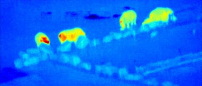
Four centuries ago, Galileo began a revolution by pointing his telescope at the sky. Now a multidisciplinary team of astrophysicists and ecologists has reversed the perspective, pointing cameras towards the Earth to help the conservation of endangered species. In this case, the revolution consists of combining the use of unmanned aircraft (drones), equipped with infrared cameras, with detection techniques used to analyze astronomical images.
An important task in conservation research is to monitor the distribution and density of animal populations, which has usually been undertaken by surveys on the ground (either on foot or by car), from the air with manned aircraft or from space using satellites. In recent years, the use of drones equipped with cameras has allowed a reduction in the costs of these studies, as well as reaching areas with difficult access.
So far, most drones studies have used cameras in the visible range (the light detected by the human eye), which has two limitations. In the first place, these cameras are useful only during day time, so that they cannot be used to monitor the large number of species that are active at night or to identify poaching. Secondly, in the visible all objects have very similar brightness, which makes it extremely difficult to make an automatic separation between the objects studied and everything that surrounds them. Infrared cameras, on the other hand, can be used both by day and by night. In addition, the difference between the body temperature of animals and the environment makes their emission in the thermal infrared range easy to separate.
However, the analysis tools in the infrared range are less developed than in the visible and, in fact, many studies use tedious manual techniques for the detection and identification of species. The study that is published today in the International Journal of Remote Sensing, has used free software of astronomical source detection and applied it to the detection of humans and different species of animals in infrared images obtained with drones. The study is led by researchers at the Liverpool John Moores University (LJMU), with the participation of Johan Knapen, a researcher at the Institute of Astrophysics of the Canary Islands (IAC).
Dr Steven Longmore, from the LJMU Astrophysics Research Institute and first author of the article, explains why this is possible: “Astrophysicists have been using thermal cameras for many decades. Crucially, it turns out the techniques we’ve developed to find and characterise the faintest objects in the Universe are exactly those needed to find and identify objects in thermal images taken with drones.” Each species has a different heat profile that acts as a 'thermal fingerprint'. “Our goal – Longmore says- is to build the definitive fingerprint libraries and automated pipeline that all future efforts in this field will rely upon.”
Johan Knapen is excited about this new application: “Not only is this a fantastic collaboration between two different fields of science: astronomy and ecology, but it also introduces the use of drones into the set of technological tools that we use to obtain thermal imaging, including space- and ground-based telescopes.”
The experience in the use of drones has been provided by Serge Wich, professor at the LJMU’s School of Natural Sciences and Psychology and the founder of conservationdrones.org. This pioneer in using drones for conservation work commented: “As an ‘eye in the sky’, conservation drones are helping the fight against illegal deforesting, poaching and habitat destruction, all leading to many species being endangered, including rhinos, orangutans, and elephants. Now, by applying the astrophysics analysis techniques used to find and identify objects in the far-distant Universe, we can try to do this more efficiently.”
Biodiversity loss and consequent ecosystem collapse is one of the ten foremost dangers facing humanity. “Ultimately – says Wich- we hope this research will help tackle these problems by allowing anyone in the world to upload their aerial data and in real time get back geolocations of anything, whether survivors of natural disasters, or poachers approaching endangered species, or even the size, weight and health of livestock.”
This new drone technology is part of the growing technological innovation within the LJMU. The Astrophysics Research Institute is also developing the world’s largest fully robotic telescope, a scaled up version of the Liverpool Telescope, located on the Roque de Los Muchachos Observatory, in the Canary Island of La Palma.
Movie: Thermal-infrared movie of a “crash” of rhinos taken from drone video footage at Knowsley Safari Park (UK). Coloured contours are the different objects (rhinos) found in the movie by the automated detection algorithm. Credits: Serge Wich, Andy Goodwin (Remoteinsights), James Crampton, Maisie Rashman, Maria de Juan Ovelar, Steven Longmore. LJMU and the Knowsley Safari Park.
Other video demonstrations of drone and thermal camera research here. Credits: Dr Steve Longmore, Professor Serge Wich, Andy Goodwin, Ron Collins, Simon Pfeiffer.
Scientific article: ‘Adapting astronomical source detection software to help detect animals in thermal images obtained by unmanned aerial systems’. International Journal of Remote Sensing. (astro-ph IM: https://arxiv.org/abs/1701.01611)


